Question 263Navigation General
70% to passWhich statement concerning the chartlet seen in illustration D010NG below is TRUE? (Soundings and heights are in meters)
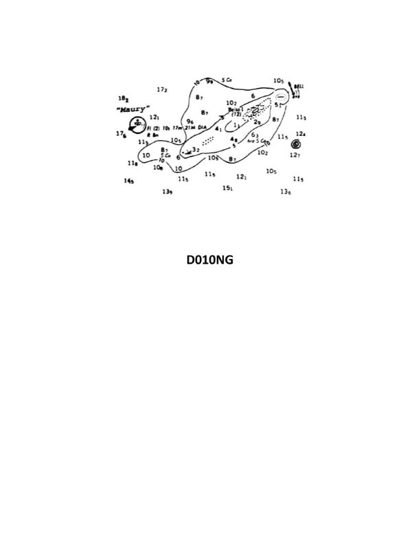
A
Maury lightship is visible for 17 miles.
B
There is a dangerous eddy southeast of Beito Island.
C
There is a 12-meter deep hole west of Beito Island and inside the 5-meter line.
D
The bottom to the south-southeast of the lightship is soft coral.
AI Explanation
The correct answer is B) There is a dangerous eddy southeast of Beito Island. The chartlet shows a hazardous eddy symbol southeast of Beito Island, indicating the presence of a dangerous eddy in that area. This is the only answer choice that is supported by the information provided in the illustration. The other answer choices are incorrect because: A) The chartlet does not provide information about the visibility range of the Maury lightship. C) The chartlet does not show a 12-meter deep hole west of Beito Island. D) The chartlet does not indicate the type of bottom material south-southeast of the lightship.
Related Questions
Q1919:You are on a voyage from New Orleans to Boston. When navigating off the Florida ...
Q482:Which symbol represents a 10-fathom curve?
Q667:The magnetic compass magnets are acted on by the horizontal component of the Ea...
Q1840:What is the relative bearing of an object broad on the port quarter?
Q380:The lock chamber is 600 feet X 110 feet. Your towboat is 150 feet X 35 feet. Whi...
Ready to test your knowledge?
Take a Navigation General Practice ExamOfficial Resources
Want to practice with timed exams?
Download Coast Guard Exams for the full exam experience.
App Store